


REFERENCE
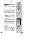
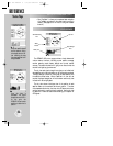
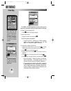
‘Searching the Sky’ means
no almanac data is stored
in the GPSMAP 195.
Almanac data tells your
unit where to find the
satellites. The receiver
will ‘search’ for satellites
and recollect the data.
‘Poor GPS Coverage’
means not enough satel-
lites are being received to
determine a position, pos-
sibly because some
obstruction is blocking the
signal.
47
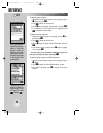
STATUS PAGE (cont.)
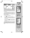
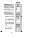
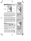
Receiver status is indicated at the top of the page, with the current
estimated position error (EPE), dilution of precision (DOP), and
battery level to the left of the sky view. DOP measures satellite
geometry quality on a scale of one to ten (lowest numbers are best,
highest numbers are worst). EPE uses DOP and other factors to
calculate a horizontal position error in feet or meters. Your GPSMAP
195 shows battery strength in two ways: a battery gauge located
below the DOP measurement and a battery icon located on the status
bar. Both methods show continuous battery level updates. The
battery gauge works like the fuel gauge in your plane or car. As
battery energy is depleted, the highlighted area of the gauge is
reduced, showing the remaining capacity. The battery icon provides
similar information by shading a portion of the icon to show the
remaining capacity. (This icon appears on every page when using
battery power. It’s not necessary to return to the status page to see
battery condition.)
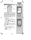
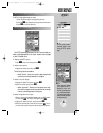
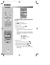
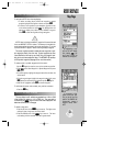
The status field will show one of the following conditions:
• Searching the Sky— the receiver is looking for any satel-
lites. This process can take 10-15 minutes.
• AutoLocate— the receiver is looking for any satellite whose
almanac has been collected. This process can take up to five
minutes.
• Acquiring Satellites— the receiver is looking for and col-
lecting data from satellites visible at its last known or initial-
ized position in order to calculate a fix.
• 2D Navigation— at least three satellites with good geome-
try have been acquired and a 2D position fix (latitude and
longitude) is being calculated. ‘2D Differential Navigation’
will appear when you are receiving DGPS corrections in 2D
mode.
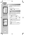
• 3D Navigation— at least four satellites have been acquired,
and your position is now being calculated in latitude, longi-
tude and altitude. ‘3D Differential Navigation’ will appear
when you are receiving DGPS corrections in 3D mode.
• Poor GPS Coverage— the receiver isn’t tracking enough
satellites for a 2D or 3D fix.
• Receiver Not Usable— the receiver is unusable, possibly
due to incorrect initialization or abnormal satellite condi-
tions. Turn the unit off and back on to reset.
• Simulating Navigation— the receiver is operating in sim-
ulator mode, and not using actual satellite data.
Status Page
gps 195 manual C 7/1/99 4:48 PM Page 47