


cGPSmapper Manual Index and Tables
http://cgpsmapper.com/ 97 of 100
10 Index and Tables
10.1 Table of Figures
FIGURE 1: LESS DETAIL MAP EXAMPLE................................................................................... 40
FIGURE 2: MORE DETAIL MAP EXAMPLE................................................................................. 40
FIGURE 3: MAP DETAIL SETUP .............................................................................................. 44
FIGURE 4: HOW NAME VARIABLES ARE SHOWN .....................................................................67
10.2 Version Control Log
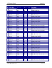
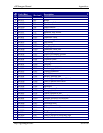
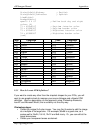
Ver# Date Edited by Section Changes
1.0 2005-04-01 M. Zalba - Initial Release
1.1 2005-04-04 H.Scheffler 2.4 Removed some author names as
requested
1.2 2005-05-23 H.Scheffler - PDF with higher resolution images
2.0 2005-07-08 M. Zalba - Added marine documentation and
updated ESRI documentation.
4.2 PFM syntax Description
Added [CHART INFO] section to the
end of the Declarations section.
4.2.1 Header
"Marine" element added.
"DrawPriority" element added.
4.2.2.4 Chart Info
New section.
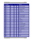
4.2.4.1
4.2.4.2
4.2.4.3
"SubType" element added to Points of
Interest, Polygons and Polylines.
4.2.4.6 Shapes
Section updated.
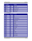
4.3 Marine Charts
New section.
8.1 cGPSmapper compilation Errors and
Warnings
Changed W014
Added: R010, R011, R012
8.3 cGPSmapper object types list
Note about the marine objects added.
8.3.1
8.3.2
8.3.3
Marine objects and their description
added.
"Find" (GPS) feature added.
8.4 cGPSmapper versions
Marine version added.
2.1 2006-10-10 G.Rikker 5 Custom TYP file