


cGPSmapper Manual Appendices
http://cgpsmapper.com/ 87 of 100
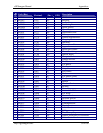
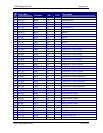
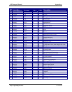
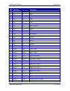
Code (Hex)
Code
(Decimal)
Filter
(Dec.)
Find
(GPS)
Description
Y 0x0307 775 3 N Tanks
Y 0x0308 776 3 N Tower
Y 0x0309 777 3 N Rock
Y 0x030a 778 3 N Triangulation point
Y 0x030b 779 3 N Radio mast
Y 0x0400 1024 4 Y Isolated danger
Y 0x0401 1025 4 Y Obstruction
Y 0x0402 1026 4 Y Wreck
Y 0x0403 1027 4 Y Exposed wreck
Y 0x0404 1028 4 Y Well
Y 0x0405 1029 4 Y Foul
Y 0x0406 1030 4 Y Explosive
Y 0x0407 1031 4 Y Fish haven
Y 0x0408 1032 4 Y Obstruction that covers
Y 0x0409 1033 4 Y Marine farm
Y 0x040a 1034 4 Y Dangerous rock
Y 0x040b 1035 4 Y No bottom found
Y 0x040c 1036 4 Y Exposed rock
Y 0x040d 1037 4 Y Dangerous rock
Y 0x040e 1038 4 Y Underwater rock (non-dangerous rock)
Y 0x040f 1039 4 Y Shoal
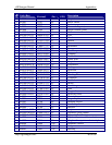
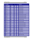
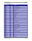
Y 0x0500 1280 5 N Label point
Y 0x0600 1536 6 N Centred label
Y 0x0700 1792 7 N Miscellaneous point
Y 0x0701 1793 7 Y Recommended anchorage
Y 0x0702 1794 7 N Pilot boarding place
Y 0x0703 1795 7 N Yacht harbour
Y 0x0704 1796 7 N Pile
Y 0x0705 1797 7 Y Anchoring prohibited
Y 0x0706 1798 7 Y Fishing prohibited
Y 0x0707 1799 7 Y Precautionary area
Y 0x0708 1800 7 N Radio report point
Y 0x0709 1801 7 N Anchorage berths
Y 0x070a 1802 7 N Rescue station
Y 0x070b 1803 7 N Fishing harbour
Y 0x070c 1804 7 N Airport
Y 0x0800 2048 8 N Information
Y 0x0901 2305 9 N Bottom conditions
Y 0x0902 2306 9 N Fishing information
Y 0x0903 2307 9 N Facility