


cGPSmapper Manual FAQs
http://cgpsmapper.com/ 69 of 100
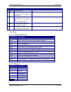
7.3 Saving Objects as [RGNx0] vs. [POI], [POLYGON], [POLYLINE]
7.3.1 Equivalences
Notation 1 Notation 2
[POLYLINE] [RGN40]
[POLYGON] [RGN80]
[POI]
City=Y
...
[END]
[RGN20]
[POI]
City=N (or no city key)
...
[END]
[RGN10]
[POI] covers both [RGN10] and [RGN20]. The difference is made with the 'City=y' key.
7.3.2 Impact of saving objects in one format or the other
There is no impact. [POI], [POLYGON], [POLYLINE] are more understandable to the
human reader.
7.3.3 Preferred method
There is no preferred method.
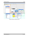
7.4 Relationship between levels in the detail maps and the preview maps
The lowest zoom level in the PV should be the highest in the detailed map.
The preview is displayed up to this switch over point.
When you zoom in more in MapSource the GPS detail map is displayed.
Example
In your detail IMG file:
Level0=24
Level1=22
...
Level4=18
Zoom0=0
Zoom1=1
..
Zoom4=4
And in the preview file: