


cGPSmapper Manual Map Project
http://cgpsmapper.com/ 43 of 100
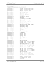
[RGN10]
Type=3328
Label=Remenham
EndLevel=3
Data0=(51.551744,-0.889936)
[END]
What the EndLevel=n line says is that the coordinates in the highest numbered Datan=
line apply up to the specified EndLevel=n, starting with the level number in the Datan=
line. In our example, EndLevel=3, combined with Data0= means that the coordinates
apply for three consecutive levels commending with level 0 (i.e. levels 0, 1, 2 and 3).
Levels and LevelsNumber are "old" equivalents of EndLevel.
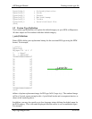
4.4.3.1 Tailoring shape according to level.
In the previous example, our map object had the same coordinates at all the levels in which
it was visible. For single point objects, there's no need for the coordinates to vary. You
don't want your village moving around the countryside as the user zooms in or out on your
map!
For lines and regions, you may wish to modify the coordinates according to zoom level.
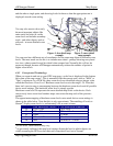
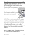
Consider the following footpath:
[RGN40]
Type=22
Label=
EndLevel=3
Data0=(51.562624,-1.070283),(51.561637,-
1.070592),(51.561272,-1.069878), (51.560059,-1.064277)
[END]
This path will be visible, and have exactly the same shape, at levels 0 to 3. Now let's
change it slightly:
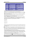
[RGN40]
Type=22
Label=
EndLevel=2
Data0=(51.562624,-1.070283),(51.561637,-
1.070592),(51.561272,-1.069878), (51.560059,-1.064277)
Data1=(51.562624,-1.070283),(51.561272,-
1.069878),(51.560059,-1.064277)
[END]
The path is still visible at levels 0 to 3 but the shape changes subtly between level zero (the
greatest detail) and level one. At level zero there are four vertices in the line. At levels one
and two this reduces to three vertices. What we are actually doing here is specifying that we
are only interested in the precise shape of the bend in the path at the highest zoom level.
Reducing the detail at higher zoom levels can reduce the size of your digital map, reducing
upload times and helping to fit in memory where otherwise it wouldn't.
In practice, you don't normally need to specify reduced detail explicitly in this way because
cGPSmapper automatically detects when there is unnecessary detail for the target zoom