


cGPSmapper Manual Creating custom type file
http://cgpsmapper.com/ 53 of 100
[_line] Definitions
Line definitions are used to replace the standard polyline types, including roads. There are
two ways to define a line. You may either declare the line’s color and thickness attributes
for its interior and border, or you may provide a custom bitmap. Both methods allow
transparency in the definitions.
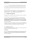
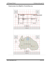
Line declaration method 1: Declare a line thickness and border thickness.
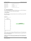
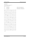
[_line]
Type=0x01
LineWidth=5
BorderWidth=1
xpm="0 0 4 0"
"1 c #20c818"
"2 c #309838"
"3 c #20c818"
"4 c #086808"
string1=0x04,Toll Road
string2=0x08,Carretera de pago
[end]
This definition specifies a replacement for polyline 0x01, Major highway. LineWidth is
specified as 5 pixels, BorderWidth is specified as 1 pixel.
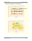
xpm="0 0 4 0" ; Define both day and night colors
(4)
This line indicates that there is no pixel bitmap, only color definitions. There are 4 colors
defined, 2 for daytime, and 2 for nighttime.
"1 c #20c818" ; Daytime interior color
"2 c #309838" ; Daytime border color
"3 c #20c818" ; Nighttime interior color
"4 c #086808" ; Nighttime border color
When describing lines using LineWidth and BorderWidth, note that the color declarations
use a different format. The first character represents either daytime interior (1), daytime
border (2), nighttime interior (3) or nighttime border (4).
As with POIs and polygons, you may use up to four language substitution strings for the
generic type description.