


cGPSmapper Manual Appendices
http://cgpsmapper.com/ 72 of 100
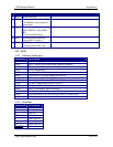
9 Appendices
9.1 cGPSmapper compilation Errors and Warnings
The table below contains a list of the different errors and warnings that could occur at
compilation time. Codes starting with either "E" or "R" apply only to routable maps. Codes
starting with "W" are warnings. Although the compilation will stop after an error occurs, it
will not stop when a warning message occurs.
This section will be further documented in a future version of this manual.
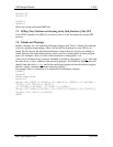
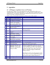
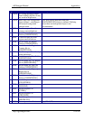
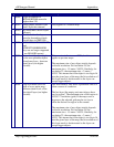
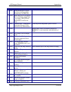
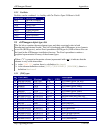
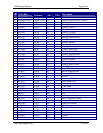
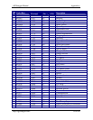
V
Code Warning / Error Text Description / Workaround
W001
Could not open include file.
W002
No zip codes file defined.
W003
No highways file defined.
W004
Cannot determine type of
element, type cannot be
defined before RGNTYPE.
W005
Error reading data.
W006
Null exit facility name for
RGN10 element.
W007
Wrong coordinates. E.g. incorrectly separated coordinates like
(2.2,3.2),,(2.2,2.3)
W008
Element spans more than 10
degrees!
W009
Invalid [WPT] section -
RGNTYPE is not defined.
W010
ELEVATION parameter is
depreciated.
W011
Invalid [PLT] section -
RGNTYPE is not defined.
W012
- no longer used
W013
TRESIZE smaller than 100.
W014
RGNLIMIT should not be
smaller than 500.
A small RGNLIMIT derives in the creation of a
bigger map, with no gain in speed.
W015
TRESIZE larger than 5000 -
TRESIZE is fixed (i.e. the
TRESIZE is automatically
changed to 5000).
When the TreSize value in [IMG ID] is too big - the
resulting map IMG file renders more and more
slowly on a GPS receiver. This value should never
be higher than 5000. If the value is larger than
5000, it is internally changed to 5000 and the
warning is shown.
Note that for a preview map, this warning won't be
shown. There is a new key in [IMG ID] to specify
that a preview map is created ('Preview=Y').
W016
- no longer used
W017
- no longer used