


cGPSmapper Manual Map Project
http://cgpsmapper.com/ 40 of 100
and the other a single point, and choosing levels for them so that the appropriate one is
displayed at each zoom setting.
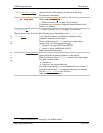
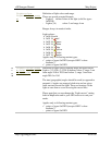
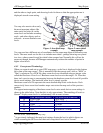
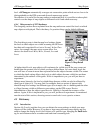
You may also want to show only
the most important objects like
main roads and cities at a wide
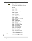
zoom level and include secondary
roads - and other objects such as
railroads - at more detailed zoom
levels.
Figure 1: less detail map
example
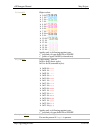
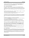
Figure 2: more detail
map example
You can even have different sets of coordinates for the same map object at different zoom
levels. The most usual use for this is to include more detail - perhaps showing every bend
in a river, when zoomed in and less detail when zoomed out. Normally this will not be
necessary though, because cGPSmapper automatically reduces the number of points in
higher zoom levels.
4.4.2 Concepts and Terminology
When you zoom in and out on your GPS' map page, a scale line is displayed in the bottom
left corner of the map screen
†
. This is annotated with the current scale, such as "800ft" or
"2km" or whatever. In a PFM file, these zoom levels are identified using an integer value
called the Hardware Zoom Level. Hardware zoom levels are in the range 1-24. Note that
there isn't a precise one-to-one mapping between the hardware zoom levels and all possible
device zoom settings. The hardware zoom level is simply a guide.
Hardware zoom level 24 represents the most detailed map levels on the device. Each
successively lower zoom level number maps onto twice the map scale of the previous
number.
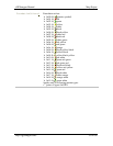
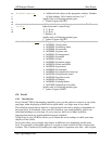
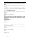
The approximate mapping of hardware zoom levels onto actual device zoom settings is
shown in the table below. Note that this is only approximate. The matching of levels to
Garmin
®
display zoom levels is, unfortunately, not an exact science.
Level no.
8
GPS Equivalent (Metric) GPS Equivalent (Imperial)
24 Up to 120m Up to 500ft
23 200m, 300m 800ft to 0.2 miles
22 500m 0.3 miles
21 800m to 1.2km 0.5 miles
20 2km 0.8 miles to 1.2 miles
†
eTrex series. Other models may vary.
8
As previously indicated, the map level settings dictate the level at which objects are
visible assuming the GPS user has their unit's map detail level set to Normal.