


cGPSmapper Manual Creating custom type file
http://cgpsmapper.com/ 50 of 100
Type=0x4e,5 ; Orchard/plantation
Type=0x4f,5 ; Scrub
Type=0x50,3 ; Forest
Type=0x51,6 ; Wetland/swamp
Type=0x52,4 ; Tundra
Type=0x53,5 ; Sand/tidal/mud flat
[end]
5.2 Custom Type Definition
Your custom type definitions will replace the default imagery on your GPSr or Mapsource.
All other objects will be rendered with their default imagery.
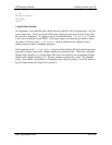
[_point] Definitions
Points (POIs) define your replacement bitmap for the associated POI type using the XPM
format. For example,
[_point]
Type=0x01
Dayxpm=”16 16 2 1”
“ c None”
“X c #000000”
"XXXXXXXXXXXXXXXX"
"X X"
"X X"
"X X"
"X X"
"X X"
"X X"
"X X"
"X X"
"X X"
"X X"
"X X"
"X X"
"X X"
"X X"
"XXXXXXXXXXXXXXXX"
[end]
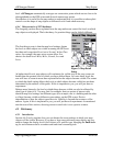
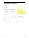
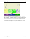
defines a daytime replacement image for POI type 0x01 (Large city). The rendered image
will be a 16 pixel square rectangle with a 1 pixel black border and a transparent interior, as
shown in the rendering above.
In addition, you may also specify up to four language strings defining the default name for
the POI category. This is the name displayed when the cursor is over an unlabeled object.
For example,