


cGPSmapper Manual FAQs
http://cgpsmapper.com/ 70 of 100
Level0=18
Level1=17
Zoom0=5
Zoom1=6
(Does not overlap with detail IMG file)
7.5 Filling (Gas) Stations not showing in the find function of the GPS
Use 0x2F01 (instead of 0x4400) if you want to show it in the find function of your GPS
receiver.
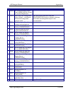
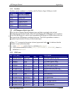
7.6 Islands and Clearings
Islands, clearings, etc. are created by defining polygons with "holes" in them. For example,
a hole in a polygon representing a lake or the sea will be displayed on your GPS as an
island. For this reason, the following technique is often referred to loosely as creating an
island. However the same technique may also be used for creating holes in other polygon
types. For example, a hole in a wood would represent a clearing and so on.
A hole can be defined in any region by including a second or subsequent Data#= line with
the same level, or layer, number as the enclosing polygon. The Data# line defining the hole
should come after the Data#= line for the enclosing polygon and should define a polygon
which is wholly contained within the enclosing polygon.
For example, here is a definition of a simple wood containing a clearing:
[RGN80]
Type=80
Label=Some Wood
Levels=3
Data0=(52.636651,2.189029),(52.844893,4.709805),(51.465289,5.
707034),(49.799352,4.128087),
(50.033624,2.853849),(51.283077,1.524209)
Data0=(51.595440,2.604541),(52.272227,3.961882),(50.762472,4.
405095),(50.710411,3.906480)
[END]