


cGPSmapper Manual Appendices
http://cgpsmapper.com/ 88 of 100
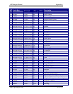
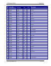
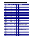
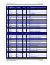
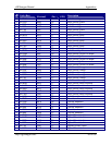
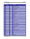
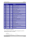
9.3.2 [POLYLINE] types
Code (Hex)
Code
(Decimal)
Description
N 0x01 1 Major Highway-thick
N 0x02 2 Principal Highway-thick
N 0x03 3 Principal Highway-medium
N 0x04 4 Arterial Road–medium
N 0x05 5 Arterial Road-thick
N 0x06 6 Road-thin
N 0x07 7 Alley-thick
N 0x08 8 Ramp
N 0x09 9 Ramp
N 0x0a 10 Unpaved Road-thin
N 0x0b 11 Major Highway Connector-thick
N 0x0c 12 Roundabout
N 0x14 20 Railroad
N 0x15 21 Shoreline
N 0x16 22 Track/Trail
N 0x18 24 Stream-thin
N 0x19 25 Time-Zone
N 0x1a 26 Ferry
N 0x1b 27 Ferry
N 0x1c 28 Political Boundary
N 0x1d 29 County Boundary
N 0x1e 30 International Boundary
N 0x1f 31 River
N 0x20 32 Land Contour (thin)
N 0x21 33 Land Contour (medium)
N 0x22 34 Land Contour (thick)
N 0x23 35 Depth Contour (thin)
N 0x24 36 Depth Contour (medium)
N 0x25 37 Depth Contour (thick)
N 0x26 38 Intermittent River
N 0x27 39 Airport Runway
N 0x28 40 Pipeline
N 0x29 41 Power line
N 0x2a 42 Marine Boundary (no line)
N 0x2b 43 Marine Hazard (no line)
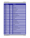
Y 0x0100 256 Miscellaneous line
Y 0x0101 257 Line
Y 0x0102 258 Cartographic line
Y 0x0103 259 Road
Y 0x0104 260 Clearing line
Y 0x0105 261 Contour line