


cGPSmapper Manual Map Project
http://cgpsmapper.com/ 44 of 100
level. cGPSmapper automatically averages out consecutive points which are too close to be
distinguishable on the GPS screen and discards unnecessary points.
Nevertheless it is useful for the map author to understand how it is possible to take explicit
control over the shape of map objects at different levels if and when necessary.
4.4.4 Idiosyncrasies of GPS hardware
The foregoing sections have explained how the map author can control the levels at which
map objects are displayed. That's the theory. In practice things can be slightly different.
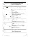
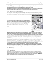
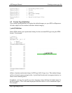
The first thing to note is that the map level settings dictate
the level at which objects are visible assuming the GPS user
has their unit's map detail level set to Normal. In the eTrex
series, for example, the map set-up screen offers five
choices for detail level: Most, More, Normal, Less and
Least.
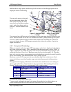
Figure 3: Map Detail
Setup
At higher detail levels, map objects will continue to be visible even if the user zooms out
further than the greatest level at which you have defined them. At lower detail levels the
user will have to zoom in more than expected before the objects become visible. The extent
to which the detail setting affects the levels at which objects become visible has not been
determined by the authors of this guide. If this is important to you, you will just have to
experiment.
Perhaps more bizarrely, the level at which things become visible can also be affected by
what type of object it is. You may find, for example, that two points of interest with
identical map level settings but different types (for example, one is a building and the other
a village) become visible at different zoom settings on the GPS screen. Precise
determination of how the object type affects its visibility is beyond the resources of the
authors. Again, if this is important to you, you will just have to experiment. As mentioned
near the start of this section, choosing correct zoom levels is not a precise science.
4.5 Dictionary
4.5.1 Introduction
Section 4.4 (Levels) explains how you can dictate the zoom settings at which your map
objects will be visible. However if you have a large map with many map objects and you
need to change the display level for all objects of a specific type, changing the EndLevel=
tag for each instance can be a cumbersome and time-consuming task.