


cGPSmapper Manual Appendices
http://cgpsmapper.com/ 74 of 100
V
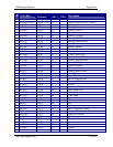
Code Warning / Error Text Description / Workaround
E018 Type of element for
RGN40/RGN80 cannot be
higher than 128.
E019 Street cannot intersect with
itself! Split this element!
Only applies to a routable map.
E020 No more than 8 active layers
allowed.
E021 Grid definition for layers
must be descending (check
Level# keys in [IMG ID]).
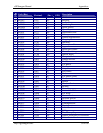
E022 STREETNUMBERSSTART
and
STREETNUMBERSEND
keys are no longer supported
- use ROADID instead.
E023 Layer detail level too high to
cover non-splittable objects
from lower layer - decrease
detail level (use higher
Level#).
This error is similar to error E024, but this error
applies to preview maps.
The maximum size of any object strictly depends
on the bit resolution. For resolution 24, the
maximum size 1.5 metre * 65535. Similarly, for
resolution 23, the maximum size 3 metre *
65535. This means that if the object is too big to fit
into the given layer of the map, the bit resolution of
this layer needs to be decreased so the layer can
accept bigger objects.
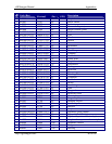
E024 Top layer detail level too
high to cover entire map -
decrease detail level of the
less detail layer (use higher
Level#).
This error needs a little more explanation since it is
often a source of confusion.
The last layer (the empty one) must always have
one 'tre region'. The maximum size of this region is
65535/2 * resolution (grid). If the map covers a
large area, the selected grid may be too low to
allow the desired 'tre region' to be created.
The maximum size of any object strictly depends
on the bit resolution. For resolution 24, the
maximum size 1.5 metre * 65535. Similarly, for
resolution 23, the maximum size 3 meter *
65535. This means that if the object is too big to fit
into the given layer of the map, the bit resolution of
this layer needs to be decreased so the layer can
accept bigger objects.