


cGPSmapper Manual Map Project
http://cgpsmapper.com/ 42 of 100
defining map objects. Map zoom level 3 is only used to dictate when our map replaces the
base map.
This means that you must always define one more map zoom level than you actually need
for your map objects, and every map definition must therefore include at least two map
zoom levels.
Having understood the relationship between map zoom levels and hardware zoom levels
you can effectively ignore hardware zoom levels during the map design process. Within the
rest of this section, the term level should be interpreted as meaning map zoom level unless
explicitly stated to the contrary.
4.4.3 Using levels when defining map objects
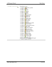
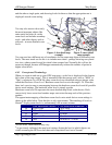
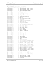
Here is an extract from a PFM file defining the village of Remenham (Berkshire, UK) as a
Point of Interest:
[RGN10]
Type=3328
Label=Remenham
Data0=(51.551744,-0.889936)
[END]
Note that the coordinate definition line starts Data0=. The digit following the word Data
specifies the level at which these coordinates will be used. This definition only specifies
coordinates for level zero. That means that the village will only be visible on the user's GPS
at zoom level zero.
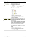
Suppose we change this to:
[RGN10]
Type=3328
Label=Remenham
Data1=(51.551744,-0.889936)
[END]
Now we have defined coordinates for level 1 only. That means that the village will be
visible only at zoom level 1. If the GPS user zooms out further than that, or if he zooms in
closer, the village will not be visible.
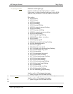
Let's say you want the village to be visible at levels zero, one and two. You could write:
[RGN10]
Type=3328
Label=Remenham
Data0=(51.551744,-0.889936)
Data1=(51.551744,-0.889936)
Data2=(51.551744,-0.889936)
[END]
However there is an easier and better way. The above definition can be abbreviated using
an EndLevel=n line: