


cGPSmapper Manual Map Project
http://cgpsmapper.com/ 46 of 100
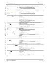
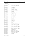
The first two lines start with ';' indicating that these are comment lines and are ignored by
cGPSmapper. They are there so that you do not need to actually count the digits to
determine which one refers to which object code.
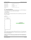
[DICTIONARY]
; 0 1 2 3 4
; 1234567890123456789012345678901234567890123
Level1RGN40=1111110000000000000000000000000000000000000
Level2RGN40=1111100000000000000000000000000000000000000
Level3RGN40=1110000000000000000000000000000000000000000
Level4RGN40=0000000000000000000000000000000000000000000
[END DICTIONARY]
[RGN40]
Type=0x01
Label=Highway N1
EndLevel=3
Data0=(51.562624,-1.070283), (51.561637,-1.070592),
(51.561272,-1.069878), (51.560059,-1.064277)
[END]
...
In the same way we can use dictionary to filter polygon [RGN80] and point of interest
[RGN10 & 20] objects by defining 'bit masks' using Level#RGN80= and Level#RGN10=.
Dictionary for POI [RGN10 and 20] objects works slightly differently in that the POI
objects are controlled in groups.
Refer to section 9.3 - on page 77 - for a list of object types with codes in hexadecimal
and decimal. Object type codes for POI consist of a group code and a subtype code. For the
decimal codes the subtype is shown in brackets after the group code.
The hexadecimal POI object codes are of the form 0x##nn where ## is the group code and
nn the subtype code.
The Dictionary filter operates on the whole group and thus 'bit mask' position ## controls
POI group ##. As far as the Dictionary filter is concerned, you can ignore the nn subtype
code.
The following PFM dictionary section will filter out all POI objects and display only dining
type POIs 0x2A00 to 0x2AFF on levels 1 to 3.
In this example the comment lines count in hexadecimal, but you can count in decimal if
you prefer.