


cGPSmapper Manual Map Project
http://cgpsmapper.com/ 17 of 100
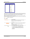
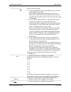
ReferenceEllipsoid
=###
Reference Ellipsoid.
0 Krassovsky
1 Airy
2 Modified Airy
3 Australian National
4 Bessel 1841
5 Bessel 1841 (Namibia)
6 Clarke 1866
7 Clarke 1880
8 Everest (Brunei)
9 Everest (India 1830)
10 Everest (India 1956)
11 Everest (W Malaysia 1948)
12 Everest (W Malaysia 1969)
13 Modified Everest
14 Fischer 1960/Mercury
15 Modified Fischer 1960
16 Fischer 1968
17 GRS 1967
18 GRS 1980
19 Helmert 1906
20 Hough
21 International
22 South American 1969
23 WGS-60
24 WGS-66
25 WGS-72
26 WGS-84
27 Unknown
[END]
Section terminator.
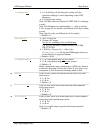
4.2.3 Advanced Declarations
The ADVANCED DECLARATIONS elements must be in the order shown herewith.
4.2.3.1 Background
[BACKGROUND]
τ π Declares a custom shape for the map – another way to
define a custom shape for the map is to use a [POLYGON]
section (or [RGN80]) as described in section 4.2.4.2 .
Name=file_name
Name of the ESRI file without extension
This should be the full or relative path for the ESRI file,
without the extension (which should be .shp for files
containing ESRI data)
[END]
Section terminator.
4.2.3.2 Dictionary
[DICTIONARY]