


cGPSmapper Manual Map Project
http://cgpsmapper.com/ 30 of 100
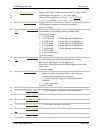
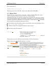
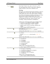
[RGN10]
Type=0x6616
Label=Table Mountain~[0x1f]1084
Origin0=(-33.96664,18.42569)
[END-RGN10]
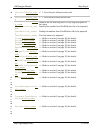
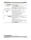
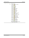
4.2.6 Road numbers
Road numbers can be defined using NUMBERS# key within [RGN40] declaration. There
could be up to 60 definitions of numbers for a single road.
Each definition consist from the NumbersX definition where X is increasing value from 1
up to 60
[RGN40]
Type=6
Numbers1=0,E,1,9,O,4,20,2999,2999,Warszawa,Mazowieckie,Polska
,Warszawa,Mazowieckie,Polska
Numbers2=3,B,21,40,N,0,0,2999,2999,Warszawa,Mazowieckie,Polsk
a,Warszawa,Mazowieckie,Polska
[END-RGN10]
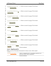
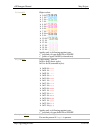
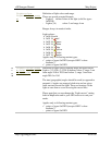
Where –
NumbersX=
[index of point in the polyline – 0 based],
[left side numbering style],
[first number on left side],
[last number on left side],
[right side numbering style],
[first number on right side],
[last number on right side],
[left side zip code],
[right side zip code],
[left side city],
[left side region],
[left side country],
[right side city],
[right side region],
[right side country]
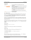
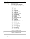
Some of the information are optional – if no zip code – it can be replaced by ‘-1’, if no city,
region and country info – also it can be replaced by ‘-1’
Numbers1=0,E,1,9,O,4,20,-1,-1,-1,-1
First ‘-1’ replaces zip code on left side, second – zip code on the right side, then ‘-1’
replaces city/region/country info on left side and the last – on the right side.