


cGPSmapper Manual Map Project
http://cgpsmapper.com/ 29 of 100
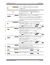
4.2.4.8 File
[FILE]
Lists other PFM files to be included in the current
compilation.
name=file_name
Name of a PFM file (including extension) to be processed in
the current compilation.
The compiler processes all the objects (and sections) in the
specified file as if they were part of the current file.
The file included may contain any section but the [IMG
ID] section.
You may specify either the full path or the path relative to
the current directory.
[END]
Section terminator.
4.2.5 Object elevation
By default, the elevation is defined in feet in PFM. To define the elevation in metres, the
Elevation=m statement should be defined in the header section ( refer to section
4.2.1 on page 9). Since this is a global definition, all elevations on a map must be in the
same units (either all in feet or all in metres).
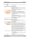
Elevation can be specified for POI objects like summit (Type 0x6616) and depth / height
points (Types 0x6200 & 0x6300) as well as for polyline objects like land / depth contours
(Types=0x20 to 0x25).
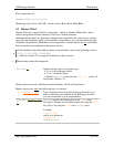
The elevation is entered in the label field of the objects. The following code extract defines
a height point with elevation of 668 m (assuming Elevation=m is defined in the header
section):
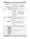
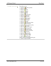
[RGN10]
Type=0x6300
Label=668
Origin0=(-33.93497,18.38925)
[END-RGN10]
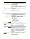
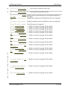
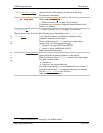
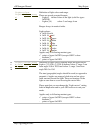
A minor land contour with elevation of 1080 m can be defined like this:
[RGN40]
Type=0x20
Label=1080
Data0=(-33.96727,18.42540),(-33.96725,18.42557),
(-33.96709,18.42600),(-33.96693,18.42624),(-
33.96682,18.42630),
(-33.96662,18.42627),(-33.96646,18.42581),(-
33.96641,18.42557)
[END-RGN40]
Text can be combined with the elevation in the label by using the ~[0x1f] delimiter to
indicate the elevation. Example of a summit with 1084 m elevation: