


cGPSmapper Manual Appendices
http://cgpsmapper.com/ 91 of 100
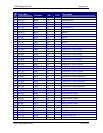
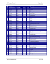
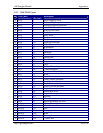
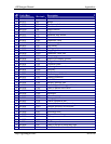
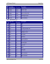
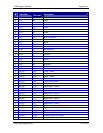
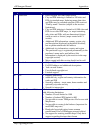
Code (Hex)
Code
(Decimal)
Description
N 0x3d 61 Lake
N 0x3e 62 Lake
N 0x3f 63 Lake
N 0x40 64 Lake
N 0x41 65 Lake
N 0x42 66 Lake
N 0x43 67 Lake
N 0x44 68 Lake
N 0x45 69 Blue-Unknown
N 0x46 70 River
N 0x47 71 River
N 0x48 72 River
N 0x49 73 River
N 0x4b 75 Background
N 0x4c 76 Intermittent River/Lake
N 0x4d 77 Glacier
N 0x4e 78 Orchard or plantation
N 0x4f 79 Scrub
N 0x50 80 Woods
N 0x51 81 Wetland
N 0x52 82 Tundra
N 0x53 83 Flats
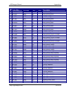
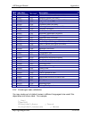
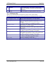
Y 0x0100 256 Land - white
Y 0x0101 257 Land - non-urban
Y 0x0102 258 Land - urban
Y 0x0103 259 Chart exclusion area
Y 0x0104 260 Chart background
Y 0x0105 261 Bridge
Y 0x0300 768 Depth area - white 1
Y 0x0301 769 Intertidal zone
Y 0x0302 770 Depth area - blue 1
Y 0x0303 771 Depth area - blue 2
Y 0x0304 772 Depth area - blue 3
Y 0x0305 773 Depth area - blue 4
Y 0x0306 774 Depth area - blue 5
Y 0x0307 775 Depth area - white
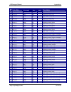
Y 0x0400 1024 Obstruction (invisible)
Y 0x0401 1025 Submarine cable (invisible)
Y 0x0402 1026 Submarine pipeline (invisible)
Y 0x0403 1027 Pile barrier (invisible)
Y 0x0404 1028 Fishing stakes (invisible)
Y 0x0405 1029 Supply pipeline area/line (invisible)