


cGPSmapper Manual Appendices
http://cgpsmapper.com/ 89 of 100
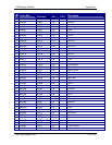
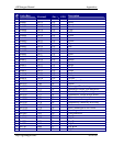
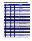
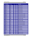
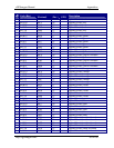
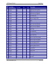
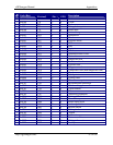
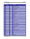
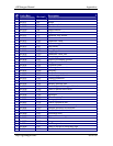
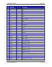
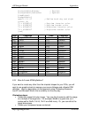
Code (Hex)
Code
(Decimal)
Description
Y 0x0106 262 Overhead cable
Y 0x0107 263 Bridge
Y 0x0108 264 Recommended route
Y 0x0109 265 Chart border
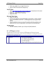
Y 0x0300 768 Depth contour
Y 0x0301 769 Depth contour value
Y 0x0307 775 Intertidal zone border
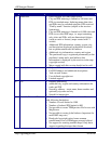
Y 0x0400 1024 Obstruction line
Y 0x0401 1025 Submarine cable
Y 0x0402 1026 Submarine pipeline
Y 0x0403 1027 Pile barrier
Y 0x0404 1028 Fishing stakes
Y 0x0405 1029 Supply pipeline area
Y 0x0406 1030 Submarine cable area
Y 0x0407 1031 Dumping ground
Y 0x0408 1032 Explosive dumping ground
Y 0x0409 1033 Danger line
Y 0x040a 1034 Overhead cable
Y 0x040b 1035 Submerged construction
Y 0x040c 1036 Pier/jetty
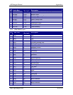
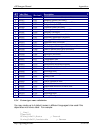
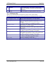
Y 0x0500 1280 Restriction
Y 0x0501 1281 Anchoring prohibited
Y 0x0502 1282 Fishing prohibited
Y 0x0503 1283 Prohibited area
Y 0x0504 1284 Military practice area
Y 0x0505 1285 Anchoring and fishing prohibited
Y 0x0506 1286 Limit of nature reservation
Y 0x0507 1287 Restricted area
Y 0x0508 1288 Minefield
Y 0x0600 1536 Miscellaneous line
Y 0x0601 1537 Cartographic line
Y 0x0602 1538 Traffic separation line
Y 0x0603 1539 International maritime boundary
Y 0x0604 1540 Straight territorial sea baseline
Y 0x0605 1541 Seaward limit of territorial sea
Y 0x0606 1542 Anchorage area
Y 0x0607 1543 Quarantine anchorage area
Y 0x0608 1544 Fishery zone
Y 0x0609 1545 Swept area
Y 0x060a 1546 Traffic separation zone
Y 0x060b 1547 Limit of exclusive economic zone
Y 0x060c 1548 Established direction of traffic flow