


cGPSmapper Manual Map Project
http://cgpsmapper.com/ 41 of 100
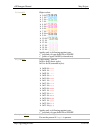
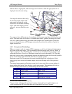
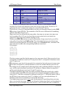
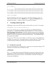
Level no.
8
GPS Equivalent (Metric) GPS Equivalent (Imperial)
19 3km 2 miles to 3 miles
18 5km to 8km 5 miles
17 12km 8 miles to 12 miles
16 20km to 30km 20 miles to 30 miles
15 50km 50 miles
14 80km to 120km 80 miles to 120 miles
13 200km to 300km 200 miles to 300 miles
12 500km to 800km 500 miles
The principle of doubling the map scale for each successive zoom number continues
beyond level 12 but lower hardware zoom levels are not really useful. Zoom level 12
represents the most "zoomed out" setting for current Garmin
®
devices.
The hardware zoom levels described above are only ever referred to directly in the [IMG
ID] section of your PFM file. The remainder of the file uses a different level numbering
scheme called Map Zoom Levels.
Map zoom levels are defined by the map author. Any map can use up to ten map zoom
levels numbered 0 to 9. If you use fewer than ten map zoom levels you should use
consecutive map zoom level numbers starting at zero.
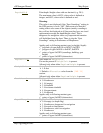
Within your [IMG ID] section you specify the number of map zoom levels you will be
using with a line of the form EndLevel=n. The relationship between your chosen map
zoom levels and the hardware zoom levels using a set of Levelm=h lines, where m is the
map zoom level and h is the corresponding hardware zoom level.
For example:
[IMG ID]
Levels=4
Level0=23
Level1=21
Level2=20
Level3=17
The above extract specifies that the map uses four map zoom levels. Map zoom level zero
corresponds to hardware zoom level 23; map zoom level 1 corresponds to hardware zoom
level 21 and so on.
The hardware zoom levels do not need to be consecutive, but each successive map zoom
level must correspond to a smaller hardware zoom level number than the previous one.
The settings in our example specify that map objects and coordinates defined as map level
zero, will be used at hardware zoom levels 23 and above. Objects defined as map level 1
will be used at hardware zoom levels 21 and 22, and so on.
The highest numbered map zoom level that you define dictates the zoom level at which
your map replaces the GPS unit's base map. In our example, the highest numbered map
zoom level is 3 and this corresponds to hardware zoom level 17. What this means is that if
the GPS device user zooms in to level 17 or higher it will see your uploaded map. At
hardware zoom levels 16 and below it will see the base map.
Your highest map zoom level is only used for the purpose of specifying when your map
takes over from the base map. You are not allowed to define map objects and coordinates at
this level. So, in our example, map zoom levels 0, 1 and 2 are the only ones available for