


cGPSmapper Manual Map Project
http://cgpsmapper.com/ 39 of 100
σ
τ
π
DoubleLights=x
Additional info shown in the properties window. Number
of light bubbles. Valid values are from 1 to 7.
Applies only to following marine types:
Points of types 0x01XX
σ
τ
π
DoubleLightsHorizo
ntal=x
Additional info shown in the properties window. Double
lights horizontal / vertical flag.
Y yes
N no
Default = N
Applies only to following marine types:
points of types 0x01XX
FacilityPoint=xxx
Facility point, sum of flags.
0x000001 boat ramp
0x000002 drinking water
0x000004 restrooms
0x000008 picnic area
0x000010 campground
0x000020 marina
0x000040 fuel
0x000080 marine supply
0x000100 bait and tackle
0x000200 groceries
0x000400 restaurant
0x000800 water/electric hook-up
0x001000 boat/motor rental
0x002000 guide service
0x004000 lodging
0x008000 dump station
0x010000 handicap accessible
Applies only to following marine types:
points of types 0x0903
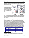
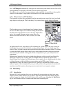
4.4 Levels
4.4.1 Introduction
Every Garmin
®
GPS with mapping capability gives you the option to zoom in or out on the
map page, either displaying a small area in great detail, or a larger area in less detail.
The selection of map objects which it is appropriate for the unit to display is dependent on
the zoom level. For example, when you are zoomed in, you would probably want to see
individual buildings on your map. As you zoom out, this level of detail would be
inappropriate because it would make the map too cluttered.
Using levels in your PFM file allows you to dictate the zoom settings at which your map
objects will be visible.
Levels also allow you to display map objects in different ways depending on the zoom
level. For example, a lake might appear as a region at some zoom levels but a single point
at others. This is achieved by creating two map objects to represent your lake - one a region