


GPSMAP
®
6000/7000 Series Owner’s Manual 39
Navigation
4. Complete an action:
• Select to navigate the route near the starting point that was used when the route was created.
• Select to navigate the route near the destination point that was used when the route was
created.
• Select to navigate parallel to the route, offset from it by a specic distance (page 44).
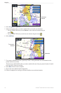
5. Select the waypoint that you want to be the next turn in your route:
• For the GPSMAP 6000 series, use the to select the waypoint.
• For the GPSMAP 7000 series, touch the waypoint.
6. Select .
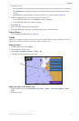
7. Review the course indicated by the magenta line.
8. Follow the magenta line, steering to avoid land, shallow water, and other obstacles.
Copying Routes
See “Chartplotter Data Management” (page 69).
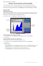
Tracks
A track is a recording of the path of your boat. The track currently being recorded is called the active track,
and it can be saved. You can show tracks in each chart or 3D chart view.
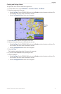
Showing Tracks
1. From the Home screen, select .
2. Select a chart or a 3D chart view.
3. Select > > > .
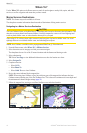
A trailing line on the chart indicates your track.
Track
Setting the Color of the Active Track
1. From the Home screen, select > > > >
.
2. Select a track color.