


14 GPSMAP
®
6000/7000 Series Owner’s Manual
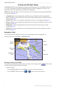
Charts and 3D Chart Views
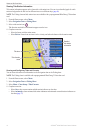
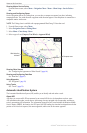
Showing Marine Service Points
From the Home screen, select > > > > >
.
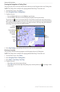
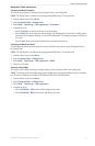
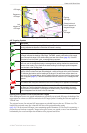
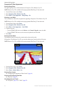
Showing and Conguring Roses
On the Navigation chart or the Fishing chart, you can show a compass rose around your boat, indicating
compass direction. True wind direction or apparent wind direction appears if the chartplotter is connected to a
compatible marine wind sensor.
: The Fishing chart is available with a preprogrammed BlueChart g2 Vision data card.
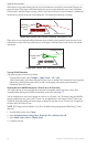
1. From the Home screen, select .
2. Select or .
3. Select > > .
4. Select a type of rose , , or .
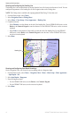
Compass rose
Wind direction
indicator
Showing Other Vessels
See “Conguring the Appearance of Other Vessels” (page 66).
Showing and Conguring Data Bars
See “Data Bars” (page 62).
Using Waypoints
See “Waypoints” (page 34).
Using Tracks
See “Tracks” (page 39).
Automatic Identication System
The Automatic Identication System (AIS) enables you to identify and track other vessels.
About AIS
AIS alerts you to area trafc. When connected to an external AIS device, the chartplotter can show some
AIS information about other vessels that are within range, that are equipped with a transponder, and that are
actively transmitting AIS information. The information reported for each vessel includes the Maritime Mobile
Service Identity (MMSI), the location, the GPS speed, the GPS heading, the time that has elapsed since the last
position of the vessel was reported, the nearest approach, and the time to the nearest approach.