


63
2. MobileMapper Office Software
Introduction
The functions supported by MobileMapper Office are listed
below:
- Creating Job files. A job should always contain a feature
library. The name of the coordinate system selected in
the program is also automatically attached to the job. The
following information will also be saved to the job if the
relevant data is displayed in MobileMapper Office:
names of waypoint/route files and name of background
map.
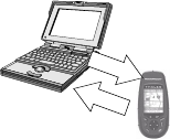
- Uploading job files to the MobileMapper handheld so
that field operators can revisit previously completed jobs.
When you do that, not only do you upload GPS positions
and descriptions of the previously visited features but
also the name of the coordinate system used in the job,
the complete feature library associated with this job, and
possibly the names of the background map and way-
point/route file attached to this job.
- Downloading completed job files from the MobileMap-
per handheld. Again, when you do that, the name of the
coordinate system used in the job, the complete feature
library associated with this job, and optionally the names
of the background map and waypoint/route file attached
to this job are downloaded in addition to the GPS posi-
tions and descriptions of the visited features.
- Exporting jobs in GIS formats (SHP, MIF, DXF). Note
that exporting to DXF requires that a grid system, not a
lat/lon system, be used in the job.
- Creating standalone feature libraries using the Feature
Library Editor. GIS layers can be imported from your
GIS system when you create a feature library.
- Creating lists of waypoints and routes using the Way-
point/Route Editor.
Conventions used
for directions
of data transfer
Upload
Download