101
Setting a Map Region
This function allows you to define the exact limits of the
background map –shown on the Map Display area– that you
wish to upload to the handheld. Using this function also al-
lows you to limit the file size of the uploaded portion of the
background map for better display performance in the field.
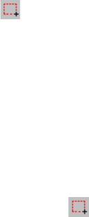
- Click on the toolbar, drag a rectangle around the
desired region in the Map Display area and release the
mouse button. The limits of the region are then repre-
sented with a rectangle with hatching on the outside. You
can still resize or reshape the rectangle by dragging its
control points (corner and mid-side points). You can also
move the whole rectangle by dragging the mouse cursor
from inside the rectangle.
- When the definition of the region is okay, click outside of
this region. The region definition is now complete and its
limits are now represented with a thick green line.
- If necessary, click again (this deletes the region you
have just defined) to redraw the region entirely.
Uploading a Background Map
After attaching a background map to the open job and possi-
bly setting a map region (see the previous two chapters), you
can now proceed with the uploading of the background map
to the handheld, to the PC’s hard disk or to the SD card in-
serted in the local SD card reader.
We’ll explain here how you can upload a background map.
You have to upload jobs and background maps separately.
Background maps are not included in the job files. Only fea-
ture libraries are actually written into job files. However, the
names of the background maps are included with the job
files so they can be displayed whenever you pick the job to
display.


