


8
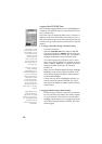
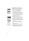
6. To complete the initialization process, press ENTER
again. The Satellite Status screen is displayed and
MobileMapper begins acquiring the data from satellites.
Watching the bars appear and turn solid on the screen,
you can progressively see the unit lock onto satellites.
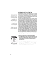
Once the first position fix has been computed, the Map
screen is automatically displayed. This screen shows a
map of the area where you are located. Your current posi-
tion is represented by a triangle located at the center of
the screen (see also page 26).
Initialization is now complete and you can proceed to
your job.
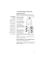
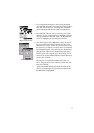
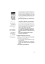
Satellite Position Graph
Satellite Signal Strength Chart
Battery Life Indicator
Satellite Positions
(W for WAAS
in the Sky & Numbers
or EGNOS)
Satellite Signal
Strength Chart:
Clear bars indicate that
the unit is starting to get
information from satel-
lites. Solid bars indicate
that the satellites are
being used to compute
your position.
Satellite Position
Graph:
The 2 circles indicate
satellite elevation as seen
from your current posi-
tion. The outer circle rep-
resents the horizon and
the inner circle repre-
sents 45° from the hori-
zon. The center of the
circle is 90° from the
horizon, or directly over-
head.