28
Select Map Info
Use this option to tell MobileMapper which data should be
displayed at the bottom of the Map screen. This can be:
-
Customize Fields. This function is equivalent to the Custom-
ize
function available from all navigation screens other
than the Map screen. See page 38.
-
Street info: This option displays an information block at
the bottom of the display showing the name of the street
your present position or cursor is on. If in the cursor
mode, the bearing and distance from your present posi-
tion are displayed.
Map Setup
You can make the following settings using the Map Setup op-
tion. To access this option, press MENU when the Map
screen is displayed, select
Setup and then select Map Setup.
The screen that appears contains two tabs: the
Format and Dis-
play
tabs.
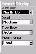
On the
Format tab, you can set the following parameters:
-
Orientation: You can change how the map is orientated on
the screen to either North Up, Course Up or Track Up.
Default is North Up.
-
Detail: Use this field to set the map detail. The detail of
the map can be set to highest, high, medium, low or low-
est. This changes the zoom level that different map
objects (cities, highways, labels, etc.) are displayed. If
you have set a zoom level and the display is too clut-
tered, set the map detail to a lower level; conversely set it
to a higher level to view more detail.
The Map screen must be
in Position mode if you
wish to customize data
fields. If the Map screen
is in cursor mode (cursor
is a cross-hair), press
ESC to return to the
Position mode
Map Setup screen,
Format tab


