


22
GPS Accuracy
MobileMapper provides better than 10-m autonomous accu-
racy around the globe assuming the receiver is tracking five
GPS satellites and the PDOP < 4 (which is almost all the
time).
If you average positions for a point feature for a few minutes,
even better accuracy is possible.
MobileMapper will warn you if your accuracy of your posi-
tions has cropped below the level you selected during Setup
(see page 54,
Alarms option). If you see this warning you may
press the ESC button and continue logging. However, if you
are recording line or area features, you might want to return
to the field when the GPS satellites are in a better configura-
tion overhead (the constellation changes slowly but con-
stantly). And if you are recording a point feature, you should
strongly consider moving to another location with better sat-
ellite reception and recording an offset (distance and bear-
ing) to the feature.
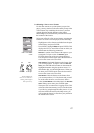
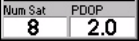
GPS Quality Indicators
On each logging screen as well as on the Satellite Status
screen, you can see at the bottom two numbers that give you
a good indication of how accurate your positions should be.
The first is the number of satellites that the receiver is track-
ing.
The second number is the Positional Dilution of Precision,
which is an estimate of accuracy that the receiver constantly
calculates using the geometry of satellites in the sky. The
more satellites that are being tracked and the more evenly
they are distributed around the sky, the better the accuracy.
PDOP values less than 4 or 5 are good. If the PDOP value is
over 10, you should consider moving to an area with a clear-
er view of the sky and recording features with offsets.
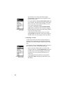
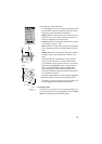
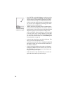
MobileMapper is also
capable of providing 3-m
horizontal accuracy
using real-time differen-
tial corrections from its
built-in WAAS/EGNOS
receiver. You must be in
North American to make
use of the free WAAS sig-
nal broadcast by the US
Federal Aviation Admin-
istration. You must be in
Europe to make use of
the free EGNOS signal
broadcast by the Euro-
pean Union. If you are
receiving a WAAS or
EGNOS signal, a “W”
appears on the screen.
GPS quality indicators
Tracking 3 satellites will
allow you to calculate a
2D position (lat/lon)
using the last altitude
recorded by the receiver.
You need to track at least
4 satellites to get a 3D
position (lat/lon/altitude)