38
Satellite Status Screen
Although the Satellite Status screen is part of the navigation
screen sequence, it is not actually a navigation screen. For
more details on this screen, refer to page 8.
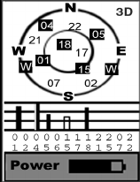
When MobileMapper is computing your position, an addi-
tional information appears in the right-upper corner with two
possible values: 3D or 2D. 3D means the computed position
is 3-dimensional (elevation computed). In 2D (2-dimension-
al), elevation is not computed. Mobile Mapper assumes that
the last computed or entered elevation is the elevation for all
computed positions.
Customizing Data Fields on Navigation Screens
Except for the Satellite Status screen, all navigation screens
can be customized through the following procedure:
• Press NAV repeatedly until the desired navigation screen
is displayed
•Press MENU
• Highlight
Customize and press ENTER. For the Map
screen, first highlight
Select Map Info and press ENTER.
Then highlight
Customize Fields and press ENTER.
• On the Navigation screen now shown in edit mode, high-
light the data field to be changed using the left/right
arrow and press ENTER
• Choose the data in the list that you wish now to display
in this field. Press ENTER. Data change in the field is
immediate.
• Resume this procedure for all the fields that need to be
changed on this screen and on the other navigation
screens.
Satellite Status Screen
Available data:
BEARING
DISTANCE
SPEED
HEADING
VMG (Velocity made
good)
CTS (Course to steer)
ETA (Estimated time of
arrival)
ETE (Estimated time
enroute
XTE (Crosstrack error)
TURN
Elevation
TIME
DATE
EPE (Estimated Posi-
tional Error)
AVG. SPEED (Average
speed)
MAX. SPEED


