


Magellan NAV 6000 87
E
Q
U
A
T
O
R
0
°
P
R
I
M
E
M
E
R
I
D
I
A
N
0
°
L
a
t
i
t
u
de
L
o
n
g
i
t
u
d
e
115°00.00W
42°30.00N
Coordinate Systems
Positions are locations that are described in a unique way so
that one location cannot be confused with another. This is
done by using a coordinate system to describe locations. Your
Magellan receiver has the ability to use any one of ten differ-
ent coordinates systems; LAT/LON (latitude and longitude),
UTM (Universal Transverse Mercator), TD, OSGB, Irish
Grid, German Grid, French Grid, Finnish Grid, Swedish Grid,
or Swiss Grid. The one you select (in SETUP) will be deter-
mined by the maps and charts you use; you would generally
want the receiver to display position coordinates in the same
system that is used by your maps.
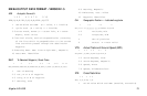
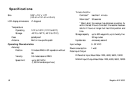
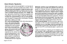
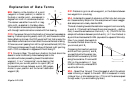
LAT/LON Coordinate System. LAT/LON is the most com-
monly used coordinate system
today. It projects lines of latitude
(parallels) and lines of longitude
(meridians) onto the earth’s sur-
face. Lines of latitude are the
equator and the horizontal lines
that are parallel to it. Lines of
longitude are the vertical lines
that are perpendicular to the
equator and pass through the
poles. A position is described as
being the intersection of a line
of latitude and a line of longitude.
Specifically, a position is up to 90 degrees north or south of
the equator (up to the poles, which are 90˚N and 90˚S; the
equator is 0˚ latitude), and up to 180 degrees east or west of
the Prime Meridian, which is 0˚ longitude. (The Prime Me-
ridian passes through Greenwich, England.) Parts of a degree
are minutes; there are 60 minutes (written as 60') to a degree.
Minutes can also be divided into smaller units. Fractions of a
minute can be expressed as decimals or as seconds. (There are
60 seconds to one minute, written as 60"). So a Lat/Lon po-
sition coordinate can be expressed in two ways, which your
Magellan GPS receiver displays as 25°47.50 or 25°47’30.
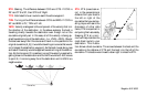
UTM Coordinate System. Another commonly used coordi-
nate system is UTM (Universal Transverse Mercator), which
is generally found on land-based maps and quad sheets that
are produced by government map providers. On land, you
may find that UTM coordinates are easier to use than Lat/
Lon.
Instead of projecting an imaginary grid of intersecting lines
onto the globe, UTM projects sections of the globe onto a
flat surface. Each of these sections is called a “zone.” There
are 60 zones to cover the entire earth between 84˚N and 80˚S
(polar areas are not described by UTM). Each zone is 6˚ wide
as projected from the earth’s center.