


Magellan NAV 6000 3
2
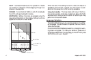
GGetting Setting Startartedted
This section shows you how to begin using your MAGEL-
LAN NAV 6000 for the first time. After a brief description of
the receiver, it discusses:
• Turning power on and off
• Adjusting contrast and backlighting
• First time use, initializing the receiver
• Navigating
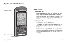
Magellan NAV 6000 Description
The Magellan GPS NAV 6000 has a high contrast, high reso-
lution backlit LCD, and backlit keypad and is designed to be
used as a hand-held or bracket-mounted.
The NAV 6000 is powered by 6AA batteries and has a built-
in antenna. A connector on the back of the unit allows you to
attach an external antenna (not included). The Power/Data
Cable (not included) can be connected to the 5-pin connec-
tor on the back of the unit for external power input and data
input/output.
Mount the unit as you plan to use it, and make all the electri-
cal and data connections before you attempt to operate it.
See the Installation section in the Appendix for details on
mounting and connecting the NAV 6000.
Keys
ZOOM IN - Changes the displayed map scale to view a
smaller area in greater detail.
ZOOM OUT - Changes the displayed map scale to view
a larger area in less detail.
CURSOR KEY - Controls cursor movement, and is used
to select menu items as well as scroll through the alpha-
numeric series for data entry. The UP/DOWN and
RIGHT/LEFT indicators on the CURSOR KEY move
the cursor or highlight in the cardinal directions, up,
down, right and left. The dots on the cursor key move
the cursor diagonally on the map display.
ENTER - Used to confirm data entry and confirm selec-
tions on the screen.
MAP/CTR - Centers the boat or cursor on the screen
and allows toggling between the boat and the cursor po-
sition. Used to display the Map screen from any screen
and centers the map on the last computed position.
GOTO - Creates a one-leg route directly to the selected
waypoint or to the cursor position.
MARK - Records the present boat position or cursor po-
sition (if the map is displayed), as a stored waypoint.