


Magellan NAV 6000 53
When Lights are turned ON under the NAV AIDS Menu,
lights will be shown on lighthouses and other lights that ro-
tate, and a light sector will be displayed to show the range of
coverage for the light. In the No Sector setting, the light will
be shown without sectors.
Use the CURSOR KEY to highlight Light Settings and press
ENTER. Use the CURSOR KEY to select Off, On - No Sec-
tor, or On - Sector and press ENTER.
Default setting: On
Complex Object Icons can be set to single (individual icons
for each object are superimposed on each other) or multiple
(one icon represents multiple objects in the same location).
Default setting: Single - Sector
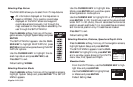
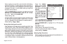
Turning Chart Settings On and Off
Chart settings on the map can be turned On and Off. They
include Lat/Lon Grid; Chart Boundaries; Waypoint Icons,
Track Display, Names of continents, countries and cities; Com-
pass, showing magnetic variation information points; Chart
Generation, showing chart generation and nautical publica-
tion information; New Objects defined in software upgrades;
Info Level, (amount of information given for each Nav-Aid
or cartographic object; can be basic or detailed) and Plot Mode
(refer to Plotter Mode in the Map Section).
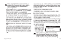
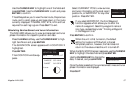
Press the MENU
softkey, use the CUR-
SOR KEY to highlight
Map Setup and press
ENTER.
Use the CURSOR KEY
to highlight Map Con-
figuration, press EN-
TER, highlight Chart
Settings and press EN-
TER.
Use the CURSOR KEY to select the feature you wish to acti-
vate or deactivate and press ENTER.
Use the CURSOR KEY to highlight On or Off and press
ENTER.
Press QUIT to exit.
Default setting: On (except Plot Mode)
The Info Level can be set to Basic or Detailed.
Default setting: Detailed
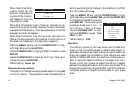
Selecting Map Orientation
When navigating on the map, there are three methods of ori-
enting the map and the boat icon.
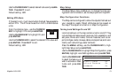
CHART SETTINGS
Lat Lon Grid On
Chart Boundaries On
Waypoint Icons On
Track Display On
Names On
Compass On
Chart Generation On
New Objects On
Info Level Det
Plot Mode Off