


Magellan NAV 6000 1
1
IIntrntroductionoduction
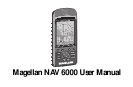
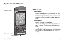
Congratulations on your purchase of the Magellan NAV 6000.
The NAV 6000 integrates the remarkable accuracy of a GPS
receiver with a broad range of electronic chart and navigation
aids into a single easy-to-use navigation information center.
The NAV 6000 uses C-MAP NT marine cartography and
can store up to 500 waypoints, and 25 routes with up to 30
legs. The large LCD display features a help bar on every screen
and can be used either with cartography or as a track plotter
to monitor progress.
This manual is divided into five chapters; Introduction, Get-
ting Started, Tutorial, Reference, and Appendix. It is very im-
portant that you go through the Getting Started chapter first
as it prepares your receiver for use and provides basic instruc-
tion for getting you up and running with your GPS receiver.
The fourth chapter is a Reference Section for the features found
in your receiver including step-by-step instructions on their
use. Because of the advanced navigational features of the re-
ceiver, some of the terminology used in these procedures may
be new to you. As you use the receiver such terms as way-
points, leg, route, etc. will quickly become familiar.
The final chapter of this manual, Appendix, contains some
further explanations and information that will help you use
your receiver and defines many of the terms that may be un-
familiar.
Packing List
The following items should be in your package:
NAV 6000 receiver
Quick Reference Card
User Guide
Carrying Case
Warranty registration card
C-Map Documentation/Ordering Information
Batteries
If any of these items is missing, please contact your local
Magellan dealer or distributor.