


Magellan NAV 6000 27
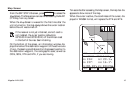
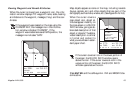
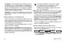
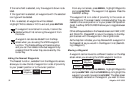
Pointer
Screen
From the NAV 2 screen, press NXT PG to access the Pointer
screen.
The Pointer screen provides a graphic compass in combina-
tion with a CDI and customizable Nav information.
At the top of the screen the name of the destination waypoint
(if any) is displayed.
The compass shows North, South, East and West designators
and overlays a road representing the course line of the active
route. Along the outer edge of the compass is the destination
waypoint icon. The boat icon appears in the center of the
compass, pointing in the direction of motion. When BRG
and COG are equal, the boat icon and the arrow will point
straight up. As the boat moves away from the active course
line, the road will shift to the right or left accordingly. If you
are off course, the road will not appear on the screen and the
Destination Waypoint Icon will represent the direction you
should head to get back on course. If the unit is not comput-
ing fixes, due to poor signal reception, the Pointer screen dis-
plays graphics based on the last COG.
Bearing (BRG), Distance (DST), Course Over Ground
(COG), and Speed Over Ground (SOG) are displayed in the
corners of the screen. These fields can be changed to include
other information using the CUSTOM softkey. The active
softkeys are MENU, ROUTES, CUSTOM and NXT PG.
The scale of the CDI (distance between the courseline and
the edge of the road) is found at the bottom of the screen and
can be changed using the right/left arrows.
Press QUIT to return to the Map screen or NXT PG to go to
the Satellite Status screen.
MENU NXT PG
Destination
Waypoint Icon
Road (represents
the courseline of
the active route)
1.0
DST
315
BRG
°
n
m
COG
346
SOG
0.0
K
t
Compass
Arrow (showing the
direction of the
waypoint icon)
Bearing
Distance
Course Over Ground
Speed Over Ground
Softkeys
Bearing
ROUTES CUSTOM
1.0
n
m
N
330
300
30
60
120
150
E
W
S
240
210
°
TO: WPT001
Boat