


Magellan NAV 600018
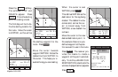
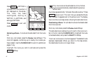
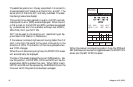
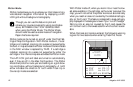
The satellites’ positions in the sky are plotted in 2 concentric
circles representing 0° elevation at the horizon, and 45°. The
center point of the circle, 90°, is directly overhead. The satel-
lites being tracked are shaded.
The current time, date, geometric quality (HDOP) and esti-
mated position error (EPE) are also displayed. When the unit
is first turned on the HDOP and EPE numbers are replaced
by underscores and the available softkeys are MENU,
ROUTES, INIT, and NXT PG.
INIT can be used to initialize the unit (see Entering an Ap-
proximate Initial Position in Reference.)
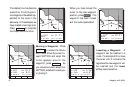
If the receiver is computing fixes and moving faster than 0.2
mph, a line from the center to the outer circle points in the
direction of COG. The direction of the line is updated when-
ever COG changes.
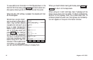
When the unit starts computing fixes, the POSITION screen
will automatically be displayed.
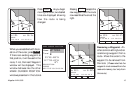
The top of the screen displays the current GPS position. Be-
low the position, HDOP, EPE, COG and SOG will be dis-
played when SOG is greater than zero. When SOG is zero,
HDOP and EPE will be replaced by AVERAGING and the
time over which the positions have been averaged.
While the receiver is computing position fixes, the POS and
SATS softkeys can be used to toggle between the POSITION
screen and the SAT STATUS screen.
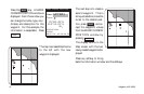
MENU ROUTES SATS NXT PG
SEP/23/97
04:27:09 PM
POSITION - LAT/LON
01 03 06 09 17 21 22 23 26
COG 032`
HDOP 2.92
SOG 60.1
K
T
EPE 032
F
T
F
T