Note that geographic names and navaid text can’t be displayed simultane-
ously at range scales greater than 2 n.m. (4 km) and that navaid text is always
available in the review window by highlighting the navaid with the cursor.
Waypoint names and lat/lon labels cannot be displayed unless the waypoints
or lat/lon grid options have been selected. The lat/lon grid will always appear
in Overzoom and No Map modes, regardless of the configuration selection.
The map display configuration windows also feature a map calibration soft-
key to provide access to a user-defined map correction function. This function
allows you to calibrate the map display to match your exact physical position
(see left for Selective Availability warning) or correct data from older charts.
If your GPSMAP is not providing an accurate display of your position
(within the estimated position error noted on the Satellite Status Page), check to see
that your GPSMAP map datum matches the datum on the chart(s) you are
using (see Section 9 for selecting a map datum). To calibrate the map display,
you must know exactly where you are, and understand that the correction is
generally valid only in a limited range from the point of correction. You
should also only perform a map calibration when your boat is not moving.
The maximum correction is 16,400 feet (5000m). Note that all map calibration
offsets will stay in effect until they are cancelled!
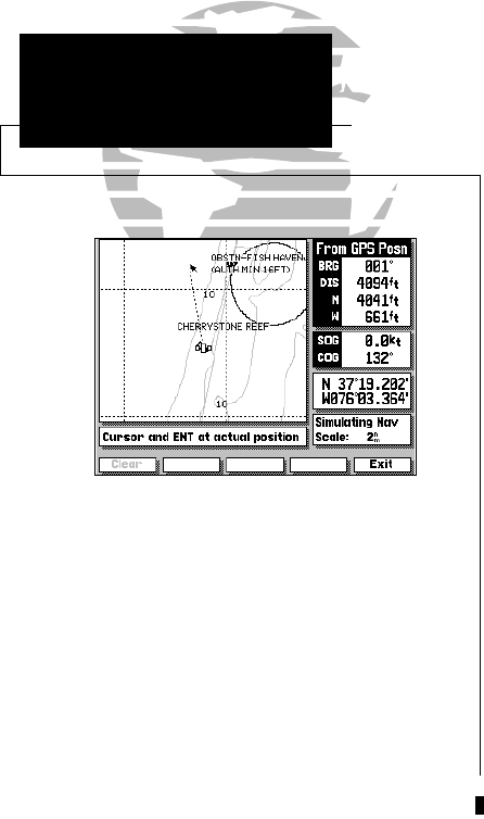
To perform a map calibration from the map configuration window:
1. Press the MAP CAL softkey.
2. Use the K key to move the arrow cursor from the satellite position (indicated
by the satellite icon) to your exact position. The bearing, distance, and horizon-
tal and vertical offset will be indicated at the top of the data window, with the
position coordinates indicated in the position field.
3. Press C to confirm the offset, and EXIT to return to the configuration window.
4. To cancel a map calibration offset, press the MAP CAL softkey. When the map
display appears, press the CLEAR softkey, followed by the EXIT softkey.
WARNING!
The map calibration function is valid only in
a limited range. The further you are away
from the point of correction, the larger the
position error will be. Keep in mind that
Selective Availability can cause position
errors up to 330 feet (100 m).
The map calibration function should NEVER
be used to attempt SA corrections. Any incor-
rect use of the calibration function can seri-
ously affect the accuracy of your unit.
24
SECTION
2
MAP CONFIGURATION
Map Calibrations
215225manb.qxd 4/27/00 9:22 AM Page 24


