


50 GPSMAP 620 and GPSMAP 640 Owner’s Manual
Marine Mode: Advanced Conguration
Wind VMG is displayed under the following conditions:
• The Sailing data bar displays Wind VMG when you are not
navigating a route or an Auto Guidance line.
• The Sailing data bar displays Wind VMG when the Route Leg
data bar is on and you are navigating a route.
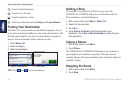
Conguring Perspective 3D Options and
Mariner’s Eye 3D Options
From the Perspective 3D screen or the Mariner’s Eye 3D screen,
touch Menu.
Waypoints and Tracks—provides access to waypoint and track
information shortcuts, as on the Navigation chart. See page 45.
NOTE: The Tracks Display conguration option is not available
on the Perspective 3D screen. You need a BlueChart g2 Vision SD
card to use this feature.
Other Vessels—provide access to AIS and DSC shortcuts, as well
as chart-specic AIS display settings, as on the Navigation chart.
See page 45.
Data Bars—control how charting numbers appear on the screen, as
on the Navigation chart. See page 46.
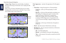
Chart Appearance—customize the appearance of the Perspective
3D or Mariner’s Eye 3D screen.
• Style—(Mariner’s Eye 3D only) select how chart data is
displayed over 3D terrain.
• Hazard Colors—(Mariner’s Eye 3D only) turn hazard colors
on or off.
◦ On setting indicates shallow water and land with a color
scale. Blue indicates deep water, yellow is shallow water,
and red is very shallow water.
◦ Off setting shows the land as seen from the water.
• Range Rings—toggle the range rings on or off.
• Safe Depth—(Mariner’s Eye 3D only) adjust the depth at which
red indicates shallow water.
• Lane Width—adjust the width of the course line drawn when
navigating. This setting affects direct navigation (Go To) and
routes (Route To), but does not affect Auto Guidance (Guide
To).