


48 GPSMAP 620 and GPSMAP 640 Owner’s Manual
Marine Mode: Advanced Conguration
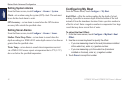
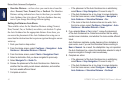
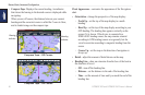
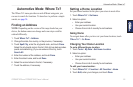
• Compass Tape: Displays the current heading. An indicator
that shows the bearing to the desired course is displayed while
navigating.
When you are off course, the distance between your current
heading and the corrected course is called the Course to Steer,
and is shaded orange on the compass tape.
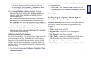
Heading
indicator
Bearing
indicator
Compass Tape – Off Course
Compass Tape – On Course
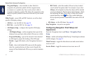
Chart Appearance—customize the appearance of the Navigation
chart.
• Orientation—change the perspective of the map display:
◦ North Up—set the top of the map display to a north
heading.
◦ Head Up—set the top of the map display according to your
GPS heading. The heading line appears vertically on the
screen if it is shown. If the device is connected to a
NMEA 0183 heading sensor, the map remains oriented
according to GPS heading (course over ground), but the
vessel icon rotates according to magnetic heading from the
sensor.
◦ Course Up—set the map so the direction of navigation is
always up.
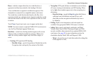
• Detail—adjust the amount of detail shown on the map.
• Heading Line—draw an extension from the bow of the boat in
the direction of travel.
◦ Off—turn off the heading line.
◦ Distance—set the distance to the end of the heading line.
◦ Time—set the amount of time until you reach the end of the
heading line.