


GPSMAP 620 and GPSMAP 640 Owner’s Manual 43
Marine Mode: Advanced Conguration
Conguring Other Vessels
From the Home screen, touch Congure > Other Vessels.
NOTE: To congure AIS or DSC information for other boats, your
unit must be connected to an external AIS or DSC device.
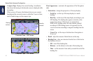
AIS—turn AIS on or off. AIS alerts you to area trafc by providing
the boat IDs, the position, the course, and the speed for boats that
are within range and equipped with a transponder.
DSC—turn DSC on or off.
AIS Alarm (AIS only)—a message banner appears and an alarm
sounds when an AIS-activated vessel enters the safe-zone ring
around your boat. The object is also labeled as dangerous on the
screen. The Off setting disables the message banner and the audible
alarm, but the object is still labeled as dangerous on the screen.
• Range—change the measured radius of the Safe Zone ring to a
specied distance from 500 ft. to 2.0 nm (or 150 m to 3 km, or
500 ft. to 2.0 mi.).
• Time To—sounds an alarm if AIS determines that a target will
intersect the safe zone within the dened time interval (ranging
from 1 to 24 minutes).
NOTE: Additional AIS and DSC conguration options are
available from the Navigation chart options. See page 45.
Conguring Navigation Settings
From the Home screen, touch Congure > Navigation.
Route Labels—for saved routes, this determines whether route
turns are indicated by number (Turn 1, Turn 2, and so on), by
waypoint name, or whether the description of turns is hidden.
Auto Guidance—Set the parameters the chartplotter uses when
calculating an Auto Guidance line.
CAUTION
The Safe Depth and Safe Height settings inuence how the
chartplotter calculates an Auto Guidance line. If an area has an
unknown water depth or an unknown obstacle height, the Auto
Guidance line is not calculated in that area. If an area at the
beginning or the end of an Auto Guidance line is shallower than the
safe water depth or lower than the safe obstacle height, the Auto
Guidance line is not calculated in that area. On the chart, the course
through those areas appears as a gray line. When your boat enters
one of those areas, a warning message appears.
• Safe Depth—set the minimum depth (using chart depth data)
allowed when calculating an auto-guidance path. A safe depth of
less than one meter is not allowed when using Auto Guidance.
• Safe Height—set the minimum height (using chart height data)
of a bridge that your boat can safely travel under.