


46 GPSMAP 620 and GPSMAP 640 Owner’s Manual
Marine Mode: Advanced Conguration
• Waypoint Display—select whether to show labels for
waypoints of a particular symbol with the waypoint name,
a comment, or a symbol only. You can also select to hide a
waypoint on charts by symbol. This allows the waypoints on the
map to be quickly limited to those most relevant to your current
activity.
Other Vessels—access AIS and DSC shortcuts, as well as chart-
specic AIS display settings.
• AIS List—view the AIS list. See page 34.
• DSC List—view the DSC list. See page 34.
• AIS Display Setup—congure chart-specic AIS display
settings.
◦ AIS Display Range—on the navigation chart, specify the
distance from your boat within which AIS icons are visible.
◦ Projected Heading—specify the amount of time ahead of
an AIS target to project the heading of the AIS target.
◦ Details—toggle AIS details on the Navigation chart on or
off.
◦ Trails—show trails behind AIS icons on the Navigation
chart for a position history of other vessels. Specify the
amount of time behind each AIS icon you want to maintain
a trail.
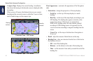
◦ DSC Trails—select the number of hours to show tracked
vessels on the Navigation chart. For example, if you select
4 Hours, all trail points less than four hours old for tracked
vessels are displayed. The Navigation chart displays a black
line indicating the path of the vessel, a black dot for each
reported position, and a
Blue Flag symbol indicating
the last reported position. Touch Off to turn trails off for all
vessels.
• AIS Alarm—set the AIS alarm. See page 43.
Stop Navigation—stop active navigation.
Conguring Navigation Chart Setup and
Appearance
From the Navigation chart, touch Menu > Navigation Chart
Setup.
Photos—enable and congure BlueChart g2 Vision high-resolution
satellite imagery. See page 12.
Tides/Currents—toggle the tide station icons and current station
icons on or off.
Service Points—toggle the marine services icons on or off.