


10 GPSMAP 620 and GPSMAP 640 Owner’s Manual
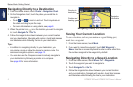
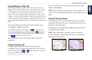
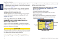
Marine Mode: Using Charts
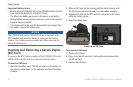
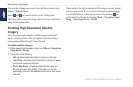
Viewing Aerial Photos
You can view aerial photos of marinas and other navigationally
signicant landmarks in the region covered by an inserted
BlueChart g2 Vision SD card.
1. On the navigation chart, touch a camera icon.
• A standard camera icon ( ) indicates an overhead photo.
• A camera icon with a cone ( ) indicates a perspective
photo. The photo was taken from the location of the camera,
pointed in the direction of the cone.
2. Touch Aerial Photo.
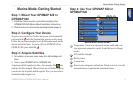
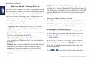
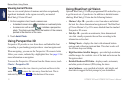
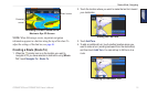
Using Perspective 3D
Perspective 3D provides a view from above and behind the boat
(according to your heading), and provides a visual navigation aid.
When navigating, you can use the Perspective 3D screen to better
follow your course, indicated by a highlighted line. See page 13 for
more information on navigation.
To access the Perspective 3D screen from the Home screen, touch
Charts > Perspective 3D.
Touch
to move the view closer to your boat and lower to the
water. Touch to move the view away from the boat. This is
indicated by the scale ( ) at the bottom of the screen.
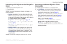
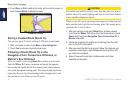
Using BlueChart g2 Vision
Optional BlueChart g2 Vision preprogrammed SD cards allow you
to get the most out of your device. In addition to detailed marine
charting, BlueChart g2 Vision has the following features:
• Mariner’s Eye 3D—provides a view from above and behind
the boat for a three-dimensional navigation aid. The BlueChart
g2 Vision Mariner’s Eye 3D is more detailed than the standard
Perspective 3D screen.
• Fish Eye 3D—provides an underwater, three-dimensional
view that visually represents the sea oor according to the
information on the chart.
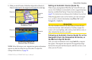
• Fishing Charts—displays the chart with enhanced bottom
contours and without navigational data. This chart works well
for offshore deep-sea shing.
• High Resolution Satellite Imagery—provides high-resolution
satellite images for a realistic view of the land and water on the
Navigation chart.
• Detailed Roads and POI data—displays roads, restaurants,
and other points of interest (POIs) along the shore.
• Auto Guidance—uses specied safe depth, safe height, and
chart data to suggest the best passage to your destination.