


18 GPSMAP 620 and GPSMAP 640 Owner’s Manual
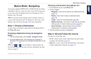
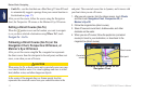
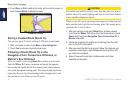
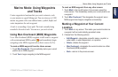
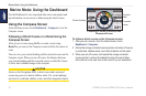
Marine Mode: Navigating
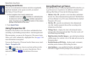
1. After you set an automatic course using Guide To, from the
Home screen, touch Charts and then touch Navigation Chart,
Perspective 3D, or Mariner’s Eye 3D.
2. Follow the magenta line from the start point to the end point.
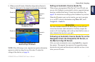
3. Steer off course to avoid land, shallow water, and other
obstacles on the water.
4. When you are off course, steer back to the magenta line when
the path is clear.
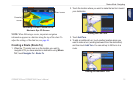
NOTE: When following a course, important navigation
information appears in a data bar along the top of the chart. To
adjust the settings of the data bar, see page 46.