


GPSMAP 620 and GPSMAP 640 Owner’s Manual 13
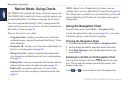
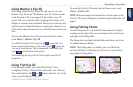
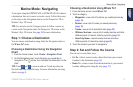
Marine Mode: Navigating
Marine Mode: Navigating
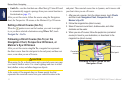
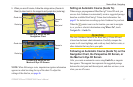
To navigate using the GPSMAP 620 or GPSMAP 640, rst choose
a destination, then set a course or create a route. Follow the course
or the route on the Navigation chart or on the Perspective 3D or
Mariner’s Eye 3D screen.
TIP: You can also use the Compass screen to follow a course or
a route on the Navigation chart, the Perspective 3D screen, or the
Mariner’s Eye 3D screen. See page 24 for more information.
Step 1: Choose a Destination
You can choose a destination using either the Navigation chart or
the Where To? menu.
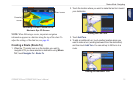
Choosing a Destination Using the Navigation
Chart
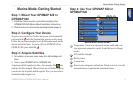
1. From the Home screen, touch Charts > Navigation Chart.
2. On the Navigation chart, touch the place you would like to
navigate to. The pointer icon indicates the destination on the
chart.
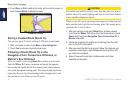
TIP: Touch and to zoom in and out. Touch anywhere on
the chart and drag to pan the map. For more information on using
charts, see page 8.
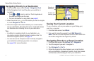
Choosing a Destination Using Where To?
1. From the Home screen, touch Where To?.
2. Touch a category:
• Waypoints—view a list of locations you marked previously
(page 19).
• Routes—view a list of routes you saved previously
(page 19).
• Tracks—view a list of recorded tracks (page 20).
• Offshore Services—view a list of nearby marinas and other
offshore points of interest, listed by proximity (page 19).
• Search by Name—search nearby marinas and other
offshore points of interest by name (page 20).
3. Touch the location you want to navigate to.
Step 2: Set and Follow the Course
You can set a course three ways:
• Go To—(direct course) create a direct line from your current
location to the destination (page 14).
• Route To—create a route from the destination to your current
location, adding turns along the way (page 15).