


GPSMAP 620 and GPSMAP 640 Owner’s Manual 49
Marine Mode: Advanced Conguration
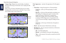
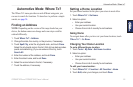
• World Map—toggle the world map (basemap) between a basic
world map and a full world map.
◦ The basic world map shows coastal outlines of the world,
with land indicated in yellow.
◦ The full world map shows the coastal outlines of the world
with the land covered in a low-resolution photo image.
• Spot Depths—turn on spot soundings and set a dangerous
depth.
• Safety Shading (with compatible BlueChart g2 Vision cards)—
areas with depths shallower than the specied value are shaded
in blue, while areas with depths greater than the specied value
are shaded in white. The contour is always drawn at, or deeper
than, the selected depth. Select Manual to enter the depth.
Select Auto to use the depth from the g2 Vision chart.
• Symbols—customize the symbols that appear on the Navigation
chart.
◦ Navaid Size—adjust the size of the symbols shown on the
map.
◦ Navaid Type—set the navaid symbol set: National Oceanic
and Atmospheric Administration (NOAA) or International
Association of Lighthouse Authorities (IALA).
◦ Land POIs—toggle Points of Interest (POI) icons shown on
land (this option is only available when using a BlueChart
g2 Vision SD card).
◦ Light Sectors—show the sector in which a navigational
light is visible. Select On to show light sectors at all times,
or select Auto to allow the chartplotter to automatically
lter out light sectors depending on the zoom level.
◦ Chart Borders—show what area the maps cover when
using a BlueChart g2 Vision data card.
Understanding How Wind VMG and Waypoint
VMG Are Displayed in the Data Bars
The chartplotter automatically switches between displaying Wind
Velocity Made Good (VMG) and Waypoint VMG in the data bars.
Waypoint VMG is displayed under the following conditions:
• The Route Leg data bar displays Waypoint VMG when you are
navigating a route or an Auto Guidance line.
• The Sailing data bar displays Waypoint VMG when you are
navigating a route or an Auto Guidance line, and you turn the
Route Leg data bar off.