


GPSMAP 620 and GPSMAP 640 Owner’s Manual 37
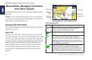
Marine Mode: Managing Information From Other Vessels
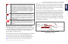
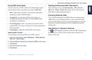
Vessel Trails on the Navigation Chart
You can view trails for all tracked vessels on the Navigation chart,
the Fishing chart, and the Mariner’s Eye 3D chart view. By default,
a black dot appears for each previously reported position of a
tracked vessel, and a Blue Flag symbol indicates the last reported
position of the vessel. A black line indicating the path of the vessel
also appears.
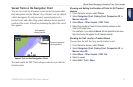
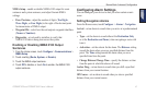
Vessel Trail on the Navigation Chart
Last reported
vessel position
Previously reported
vessel positions
You must enable the DSC Trails setting in order to view trails for
tracked vessels.
Showing and Setting the Duration of Trails for All Tracked
Vessels
1. From the Home screen, select Charts.
2. Select Navigation Chart, Fishing Chart, Perspective 3D, or
Mariner’s Eye 3D.
3. Select Menu > Other Vessels > DSC Trails.
4. Select the number of hours to show tracked vessels on the
chart or 3D chart view.
For example, if you select 4 Hours, all trail points that are less
than four hours old appear for all tracked vessels.
Showing the Trail Line for a Tracked Vessel
You can show the trail line for a specic tracked vessel.
1. From the Home screen, select Charts.
2. Select Navigation Chart, Fishing Chart, Perspective 3D, or
Mariner’s Eye 3D.
3. Select Menu > Other Vessels > DSC List.
4. Select a vessel.
5. Select Edit > Trail > Show.