


GPSMAP 620 and GPSMAP 640 Owner’s Manual 9
Marine Mode: Using Charts
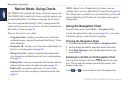
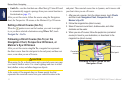
Interacting with Objects on the Navigation
Chart
1. Touch a point on the Navigation chart.
2. Touch an option:
NOTE: The options that appear are dynamic and depend on the
point you touched.
• Review—view details of the chart objects near the pointer.
(Review only appears if the pointer is near multiple objects
on the chart—if the pointer is near only one object, the name
of the object appears instead of Review.)
• Navigate To—view the navigation options (page 13).
• Create Waypoint—marks a waypoint at the location of the
pointer (page 22).
• Information—view additional information about an object or
an area of the chart.
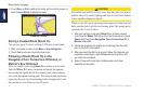
• Measure Distance—view the distance and bearing of the
object from your current location. The information appears
in a window on the upper-left corner of the screen. Touch
Set Reference to measure from a location other than your
current location.
NOTE: You can touch and drag the pointer to a new location.
Accessing Additional Object or Chart
Information
1. Touch an object on the chart or an area of the chart.
2. Touch Information, and choose from the following options:
• Tides—view tide information provided by the tide station
closest to the object or area of the chart (page 26).
• Currents—view current information provided by the current
station closest to the object or area of the chart (page 26).
• Celestial—view sunrise and sunset almanac data for the
object or area of the chart (page 27).
• Local Services—view a list of the marinas and marine
services closest to the object or area of the chart.
• Chart Notes—view National Oceanic and Atmospheric
Administration (NOAA) information associated with the chart
containing the object.