


GPSMAP 620 and GPSMAP 640 Owner’s Manual 47
Marine Mode: Advanced Conguration
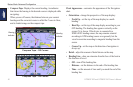
Roses—indicate compass direction, true wind direction, or
apparent wind direction oriented to the heading of the boat.
True wind direction or apparent wind direction appears if the
chartplotter is connected to a compatible marine wind sensor.
True wind shows wind direction data based on the ow of air
experienced while on a stationary boat. Apparent wind shows wind
direction data based on the ow of air experienced while on a boat
in motion.
Touch None if you do not want a rose to appear on the chart.
NOTE: You must connect an optional NMEA 0183 wind sensor to
view the True Wind and Apparent Wind roses.
Data Bars—control how charting numbers appear on the screen.
Choose to show or hide the numbers by category. When set to
Auto, the overlay numbers appear only when that category is
active.
• Cruising: GPS speed and GPS heading.
◦ Data Bar Setup—specify the position of the data bar on the
Navigation chart, and specify the contents of the elds.
• Navigation: GPS speed, distance to destination, arrival (time),
off course, bearing (to destination), and GPS heading. When
set to Auto, these numbers appear only when navigating to a
destination.
◦ Data Bar Setup—toggle the Route Leg data eld (shows
additional route information) and specify how each
data eld provides navigation information (by time or
by distance).
• Fishing: Depth, water temperature, and water speed are
available if an appropriate NMEA 0183 sensor is attached.
• Sailing: Water speed, wind speed, wind angle, and Wind
Velocity Made Good (VMG). Wind speed, angle and VMG
are only available when connected to an optional NMEA 0183
wind sensor. See page 49 for more information on how the
chartplotter displays Wind VMG and Waypoint VMG.
◦ Wind—choose the type of wind data used in the sailing data
elds (apparent or true).