


GPSMAP 620 and GPSMAP 640 Owner’s Manual 17
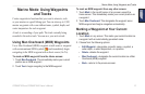
Marine Mode: Navigating
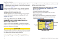
5. When you are off course, follow the orange arrow (Course to
Steer) to steer back to the magenta and purple line (route leg).
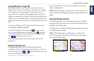
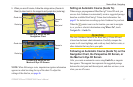
Following a Route on the
Navigation Chart
Route leg
Course to
Steer
Start point
Route turn
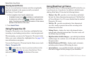
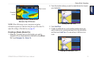
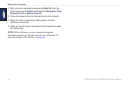
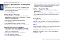
Following a Route on the
Mariner’s Eye 3D Screen
Route leg
Course to
Steer
Route turn
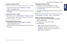
NOTE: When following a route, important navigation information
appears in a data bar along the top of the chart. To adjust the
settings of the data bar, see page 46.
Setting an Automatic Course (Guide To)
When using a preprogrammed BlueChart g2 Vision SD card, you
can use Auto Guidance to automatically create a suggested passage
based on available BlueChart g2 Vision chart information. See
page 42 for instructions on setting up Auto Guidance for your boat.
When the
pointer icon is on the location you want to navigate
to, or you have selected a destination using Where To?, touch
Navigate To > Guide To.
CAUTION
The Auto Guidance feature of the BlueChart g2 Vision SD card
is based on electronic chart information. Carefully compare the
course to all visual sightings, and avoid any land, shallow water, or
other obstacles that may be in your path.
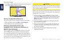
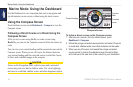
Following an Automatic Course (Guide To) on the
Navigation Chart, the Perspective 3D Screen, or
the Mariner’s Eye 3D Screen
After you create an automatic course using Guide To, a magenta
line appears. The magenta line represents the suggested passage
between the start point and the end point, and does not move, even
when you are off course.