


12 GPSMAP 620 and GPSMAP 640 Owner’s Manual
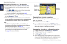
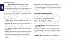
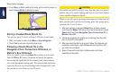
Marine Mode: Using Charts
To access the Fishing chart screen from the Home screen, touch
Charts > Fishing Chart.
Touch
and to zoom in and out on the Fishing chart.
You can navigate using the Fishing chart just as you would when
using the Navigation chart.
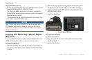
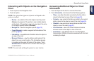
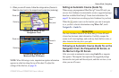
Enabling High-Resolution Satellite
Imagery
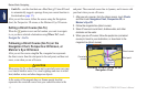
You can overlay high-resolution satellite images on the land,
the sea, or both portions of the Navigation chart when using a
preprogrammed BlueChart g2 Vision SD card.
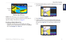
To enable satellite imagery:
1. While viewing the Navigation chart, touch Menu > Navigation
Chart Setup > Photos.
2. Touch one of the following:
• Off—standard chart information is shown on the map.
• Land Only—standard chart information is shown on water
with photos overlaying the land.
• Photo Map Blend—photos overlay both the water and
the land at a specied opacity. The higher you set the
percentage, the more the satellite photos cover both water
and land.
When enabled, the high resolution satellite images are only present
at lower zoom levels. If you cannot see the high resolution images
in your BlueChart g2 Vision region, zoom in by touching , or
set the detail level higher by touching Menu > Navigation Chart
Setup > Chart Appearance > Detail.